
Window to Chiang Mai Thailand

Window to Chiang Mai Thailand
Elephant Care & Trekking Tours
(One Day)
Wiang Kum Kam
Wiang Kum Kam (wiang goom garm) was a settlement long before it became King Mangrai's capital around 1287-90. Frequent flooding caused Mangrai to move, but the place remained important throughout the Lanna period. The site was later buried under mud when the river changed course during the Burmese period. The area was restored as a historical park during the 1980's. Surrounded by paddy and village houses, the extensive site has a pleasant rural feel, yet it is very close to Chiang Mai. The best way to see it is by bicycle or motorcycle.
Continue on Koh Klang Road past Wat Chedi Liam, to reach the McKean Institute. Follow the river to Ban Pa Dua for a pleasant rural ride and to see woodcarving.
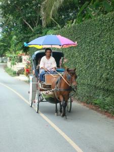
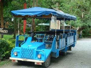
At the Wiang Kum Kam Information Center, Wat Chedi Liam and Wat Chang Kam you can make a tour with a horse carriage (200 THB per carriage per tour) or with a tram (20 seats, 1-5 persons 250 THB, 6-10 persons 300 THB, 11-15 persons 350 THB, 16-20 persons 400 THB per tram per tour).
At the information center you can also rent bicycles (20 THB) or take a look at the Wiang Kum Kam Museum (10 THB).
The tours visit the following sites excluding Wat Sri Bun Ruang
See location at Google Maps: Wiang Kum Kam Information Center
Wat Sri Bun Ruang
See location at Google Maps: Wat Sri Bun Ruang
The old viharn of this temple has been given a new roof and is brightly decorated. The result is an ornate and very colorful building that mixes the old and the new.
Wat Chedi Liam
See location at Google Maps: Wat Chedi Liam
(Koh Klang Road)
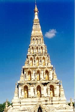
The main feature of interest is the Haripunchai style chedi built around 1286. It is a square stepped chedi with Buddha images in niches at each level.
The chedi is a replica of the Mahapol Chedi at Wat Chamadevi in Lamphun.
Wat Phra Chao Ong Dam - Phaya Mangrai
See location at Google Maps: Wat Phra Chao Ong Dam - Phaya Mangrai
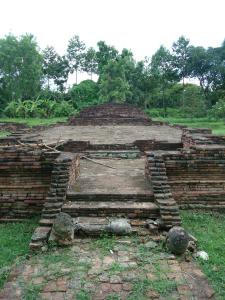 The temple got the name Wat Phra Chao Ong Dam (pra jou ong dum), which means in northern dialekt "Temple of the Black Buddha Image", from a burned bronze Buddha image found there. The other name, Phaya Mangrai, given by locals, refers to the king who established Wiang Kum Kam.
The Department of Fine Arts excaveted and restaurated the temple in 1989 - 1990.
The remains of the Phra Chao Ong Dam group consist of a viharn, a chedi and square bases. The viharn was built in a rectangular shape. A balustrade at the front stairway of the viharn has a spiral design made of stucco called "Tua Ngao" (dtua ngou, a kind of Thai decorative pattern). The chedi, located at the back of the viharn, was formed in a sqare base with indendet corners on top of an unadorned lower base. To the south of the viharn are 3 rectangular bases connected by a pathway.
The remains of the Phaya Mangrai group, located to the south of the Phra Chao Ong Dam group, are a porch of the main entrance, a boundary wall, a viharn, a chedi and an ordination hall (Ubosoth). The chedi, located at the back of the viharn, has a square base with indented corners that support a relic chamber with a niche for a Buddha image in each direction.
About 100 meters east from these monument a trace of the old Ping River, a dike and a small pavillion still remain there.
The monuments suggest that this temple was in the past a big monastery and the most important one in Wiang Kum Kam. However, most of its structures may have been covered by earth or are completely destroyed.
This temple was built twice and is dated to the 15th to 17th centuries.
Wat That Khao
See location at Google Maps: Wat That Khao
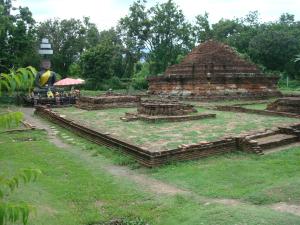 Locals, referring to the white chedi which must earlier been coated with lime, have given the temple the name "That Khao" (tart kou). The Department of Fine Arts started excavation in 1985 and found a viharn in front of the chedi. Behind the chedi was a worship altar. To the south of the viharn ruins of a building had been found speculated to have been the rite pavillion. Behind the rite pavillion parts of a Buddha image had been found. This image would have been made of brick and coated with lime. The present main Buddha image of the temple had been contributed by locals - it does not contain any of the parts of the old one. A Fak Kham (fuck karm) alphabet plate dated in the 16th century and Haripunchai style Buddha amulets dated in the 15th century were also found there. There must be still other sructures in the compound, however, the excavation work can not be continued due to land ownwership conflicts.
The restauration was finished in 1986.
From its architecture it could be speculated that this temple was built around the 16th - 17th century.
Wat Pu Pia
See location at Google Maps: Wat Pu Pia
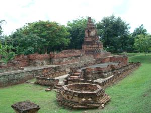 The name "Pu Pia" (pboo pbia) has been given by locals; the official name of this temple does not appear in any historical documents. The chedi of this temple has been left in near-complete condition and was the only visible part before excavation. Other parts were overgrown with bushes and a longan tree on a mound about 1.5 to 1.8 meters high.
The Department of Fine Arts started excavation of the temple in 1985 and found a viharn in front of the chedi. Evidence shows there were 2 constuctions on top of each other. There was a rite pavillion north of the viharn set by red sand-stone boundary stone slabs. To the northeast of the rite pavillion, an octagonal building was found with a worship altar nearby. The chedi has a tall base, a body with 4 niches for Buddha images on each side and is topped with a small bell shape. Each niche has beautiful decorative stucco spiral and floral designs.
The excavation and restauration was finished in 1986, though it is believed there must be other buildings, such as a wall. However, the excavation work can not be continued due to land ownwership conflicts.
From its architecture it can be assumed that this temple was build around the 16th to 17th centuries.
Wat E-Kang
See location at Google Maps: Wat E-Kang
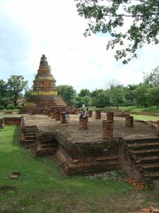 The grounds of Wat E-Kang (e kung) used to be deserted and overgrown, inhabited only by monkeys of the cercotithecidae species. Kang means monkey in northern dialekt, thus the locals call this temple Wat E-Kang. The Department of Fine Arts started the excavation work in 1985 and found a chedi behind a viharn which faces north towards a branch of the Ping River. Later in 2003 the excavation team found traces of a wall in the west of the chedi. More excavation work is done.
The chedi of Wat E-Kang remains mostly intact. It is a bell-shaped chedi on a high lotus base with torus moulding and is situated on the same base as the viharn. The base of the chedi is wide enough for a ritual walk around. Of the viharn only a big base is left. On the floor of the viharn are traces of bases for 16 pillars. There are stairways in front and on one side of the viharn, decorated with northern spiral designs (Tua Ngao, dtua ngou in the northern dialect).
The study of soil layers at Wat E-Kang ignited the first study of floods at Wiang Kum Kam. Evidence shows that there was a great flood which brought layers of different soils to the area. Other regular floods also contributed to the layers of sand, fine sand and gravel. Ancient artifacts dated from the 16th - 17th centuries, such as broken pieces from terra-cotta products from the Sankhampaeng and Wiang Kalong kilns were also found there. These parts had been scrubbed until the edges became smooth and had been buried among the layers of sand and soil. It is estimated that the flood that brought about the sediments and ancient artifacts took place in the 17th century or after.
From the architecture and the fact that plates of Fak Kham and Lanna Dhamma alphabets were found in the area, it is estimated that this temple is dated back to the 16th - 17th centuries.
Wat Nan Chang
See location at Google Maps: Wat Nan Chang
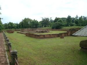 Wat Nan Chang (narn charng) is an evidence for flooding in the past at Wiang Kum Kam. The 1.80 meters deep layers of sand and soil sediments were excavated in 2002 to 2003. Revealed were ruins of buildings similar to other temples in Wiang Kum Kam. Yet this temple is different in that there were 2 buildings of 2 periods on top of each other.
In the first period, a porch of the main gate and a wall had been built around a viharn and a chedi. In the second period the grounds of the temple were extended; the wall at the back was demolished and more buildings were constructed. The excavation team found ruins of a building of a square structure with 4 arches and a pointed tip. The stairway of this building features Makara (a mixed mythical creature of crocodile, dolphin and elephant pouring out a Naga (serpent) head from its mouth). This building was built on top of the demolished part of the wall from the first period. In the second period the wall was extended to envelop the buildings.
This temple is called Wat Nan Chang to honour the ancesters of the owner of the land. One interesting thing about this temple is that it faces north while other temples face east. It is speculated that it was built to face the now dried up Ping River, which was a transportation / travel route of the time. Apart from the Makara at the stairway, other beautiful stucco works found include designs of mythical creatures such as Kilen (a Chinese mixed creature of dragon, deer, cow and horse), Haemaraja (a mixed creature of lion and swan) and Singha (lion-like beasts). Those were found under the middle of the pedestal base of the main Buddha image inthe viharn.
In addition some Chinese ceramics of the Ming Dynasty (1368 - 1644) were found. Those were found at 2 different places; the pieces of the first place consists of 47 pieces neatly arranged in a jar and intentionally buried between the building with the square structure and other buildings. This might have been because the people needed to escape from war; later the sediments from the floods buried the jar. One of the pieces is is from the royal kiln of emperor Ta Ming Wan Li (1573 - 1619). At this time Chiang Mai was under Burmese rule. At the other place were 8 pieces found buried in the flood sediments in an area speculated to have been an earthen flood wall north of the temple. These ceramics are evidence of Wiang Kum Kam's relation with China and gave answers to many historical uncertainties about Wiang Kum Kam.
The temple is dated around the 16th to 17th centuries.
Wat Chang Kam
See location at Google Maps: Wat Chang Kam
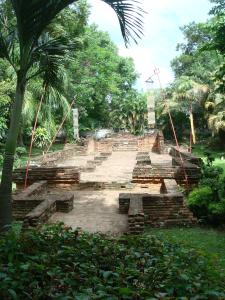 It is believed that Wat Chang Kam (charng kum, elephants carrying) was Wat Kan Thom (garn tome). It was named Kan Thom after the builder who built this temple whose name appears in several legends and chronicles. According to the Yon (yone) chronicles, Phaya Mangrai had the temple built in 1290. The chedi was 18 meters high with a 12 meters wide base. There were two-tiered niches for the 4 directions. The lower tier of each niche housed a seated Buddha image, the upper tier housed standing statues of Phra Mokala, Phra Sarebuth, Indra and the Mother Goddes, respectively. There is a Bhodi (poe) tree, but there is no evidence that this tree is the sacred Bhodi tree described in the chronicles.
The Department of Fine Arts started the excavation of the temple in 1984 and found a viharn and a chedi of square structure with 4 arches and a pointed tip, situated on a low base. Terra-cotta Buddha plates of Hariphunchai (hurrypoonchai) style where found buried around the base of the viharn. The viharn and the chedi are estimated to be built around the 15th to 16th centuries. Moreover there was another bell-shaped chedi believed to have been renovated by a Burmese benefactor around the same time he did Wat Chedi Liam. This chedi featured crouching elephants shouldering the base of the chedi, thus the locals call this temple Wat Chang Kam.
Importent ancient artifacts found there are red sandstone plates with three kinds of alphabets:
McKean Institute
See location at Google Maps: McKean Institute
(KM.4 Koh Klang Road. Hours. 08:00-16:30. Tel: 817170)
This former leprosarium is a rehabilitation center set in beautiful, quiet grounds next to the river. Colonial-style architecture includes a church with flying Buttresses. The institute plans to open a museum in a building restored to its original 19th century condition.
Information about the institute is available at the office.
See also:
Rural Rides Forest Conservation Rice Barns
Sightseeing Guide
Wiang Kum Kam & the east bank of the Ping River