
Window to Chiang Mai Thailand

Window to Chiang Mai Thailand
Elephant Care & Trekking Tours
Protected by the moats, the old city is filled with monuments that mark the course of change in the city's seven hundred year history. Generations have trod the narrow lanes that link the quiet neighborhoods to the temples and the markets. Along the main streets, trade has been the lifeblood of the city; but it is the spiritual and artistic striving focused at the temples that has given beat to city's enduring heart.
Historic Monuments
King Mangrai founded Chiang Mai at the location of a small Lawa settlement known as Wiang Nophaburi. The site lay between the river to the east and Doi Suthep mountain to the west. The proximity of the river was favorable to trade as well as political control of the area. Free from flooding, the site also had a good timber and water supply and enough land for rice farming to sustain the population. Finally, the omens were favorable.
Chiang Mai was founded on April 12, 1296 with the name of Nophaburi Sri Nakhorn Ping Chiang Mai. The plan called for a square formed by moats and walls that faced the cardinal directions. Work began at the Sri Phum corner in the north-east, which is considered the most auspicious of the four corners.
The Old City - Walls and Gates
Unlike earlier Thai Yuan settlements which were oval, the astrological plan for Chiang Mai 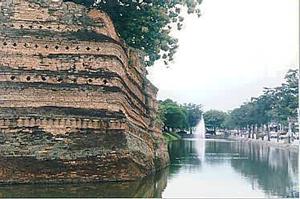 called for rectangular moats measuring 18 meters across, with a width of 1800 meters and a length of 2000 meters. Earth from the moats formed ramparts.
At the center was Chiang Mai pillar. In Brahmanic cosmology this represented Mount Sumeru, the upward link to heaven at the center of the universe (this plan was also mirrored in temples where the stupa - the chedi - stood at the center). Chiang Mai walls and moats were oriented to the cardinal points and symbolized the mountains and seas of the outer universe.
The fate of Chiang Mai was believed to depend upon the relationship between the center and the outer guardians at the corners and the gates.
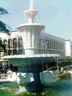 To this day ceremonies are held simultaneously at the cardinal points to propitiate these spirits.
The north of the city, was considered the head of Chiang Mai and Chang Phuak Gate was used by royalty on state occasions. The south was the rear. Originally only four gates were built, and people would enter Chiang Mai after crossing the moats on bamboo bridges which could be withdrawn at night.
A further gate was later added in the 15th century. This was Suan Prung gate, which King Sam Fang Kaen built to allow his mother to travel easily from her palace to supervise the building of the Chedi Luang. This also became the gate to be used for funeral processions from the city.
As Chiang Mai prospered, villages located near the outer walls, particularly to the south and west, became extensions of the city. Merchants set up businesses along the roads (now Thapae Road and Chang Moi Road) from the landings and bamboo bridges on the river, forming the commercial heart of the city. To protect them an outer system of defense known as the kamphaeng din was added some time after restorations to Chiang Mai walls were carried out in 1519.
During the two centuries of Burmese occupation, there is little evidence of the city's development. The fortifications seen today were rebuilt by Chao Kawila after he liberated Chiang Mai at the end of the 18th century. To defend against further attacks by the Burmese, he added the bastions at each corner.
The Old City Today
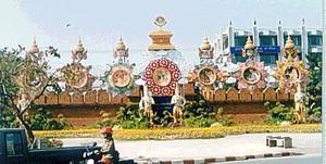 Barring minor restoration, the overall shape of the bastions on the corners are much as Kawila had built them. At some stage early in the 20th century, the walls and gates between the corners were dismantled to open up the city, and the bricks were used to pave the roads.
In 1996-7 archaeological excavations were made before the walls near the gates were extensively renovated. At the north-east corner the excavation site has been covered with a roof and left open. Bricks dated Buddhist Era 2539 (1996) were placed regularly in the new brickwork.
The present gateways were reconstructed in the late 1960s. Reflecting the importance of commerce, the most commonly used gate for city events today is Thapae Gate. The open concourse in front of the gate is used for anything from beauty contests to political rallies. At each of the corners and gates, modern inscriptions in English give information about each place. These may be found facing the road on the outer side of the moats.
The Three Kings Monument and the old city center
See location at Google Maps: Three Kings Monument
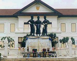 The Three Kings Statue is in front of the old provincial hall very close to the center of the old city. At the south west corner of the square on Inthawororot Road is the site of the former temple and original location of Chiang Mai pillar - Wat Sadoe Muang, which means "temple of the navel of the city". According to legend the site was a former grove where Mangrai saw two fearless white deer drive off a pack of hunting dogs. He took this as an auspicious omen for the siting of the city
The only remains of the temple are two chedi. An inscription nearby dates the octagonal chedi back to the 14th century. The Buddha images under the shelter go back to the time of Kawila.
Behind the monument stands the old provincial hall. It was converted into an Art and Culture Hall. Across Phrapokklao Road to the east stands the Chiang Mai magistrate court.
On the north-east corner of the Phrapokklao - Ratwithi intersection is Yupparat School, which was built on the grounds of the former palace of the kings of Chiang Mai. The wooden building that stands at the corner near the intersection is the former stable for white elephants - a symbol of power and nobility - belonging to former Chao.
The high school, which was founded in 1899, is one of Chiang Mai's oldest schools. It has been at this site since 1922 and now has nearly three thousand students. A small shrine to King Mangrai stands south on Phrapokklao Road, where it crosses Ratchadamnoen Road. The spot where King Mangrai was thought to have been struck by lightning is a few meters down a short lane just north of the intersection.
Minor Historic Sites
Chiang Mai has several places of historical interest that are either small or remote. You may not find them worth a visit unless you have a special interest, or happen to be nearby.
The Kamphaeng Din
See location at Google Maps: Kamphaeng Din
Kamphaeng Din is the Thai name for an extensive earthen rampart that protected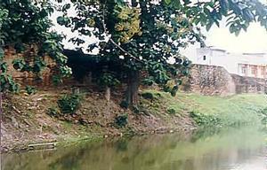 settlements beyond Chiang Mai walls to the south and east. Phra Mekuti may have first constructed the wall and redirected local streams to form moats as an outer defense. Some remains may be seen on Kamphaeng Din Road, but other remnants are largely hidden away behind houses.
An interesting area to see them is in the lanes south of Wat Nantaram, which is famous for its herbal medicines. A walk northwest from the temple up Wualai Soi 3 takes you to Wat Muen San and the silver making area along Wualai Road.
Khuang Chang Phuak
See location at Google Maps: Khuang Chang Phuak
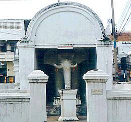 White Elephant Terrace occupies a traffic island next to Chang Phuak bus station. Local people believe that the half-elephant figures inside the arched shelters protect Chiang Mai from enemies and demons.
The present structures were built by Kawila in 1800. However, an earlier shrine may have existed to commemorate the deeds of two retainers who carried King Saen Muang Ma to safety after his army attacked Sukhothai forces and were defeated in 1387-8. The servants were rewarded with the titles of "Lord Elephant of the Left Side/Right Side".
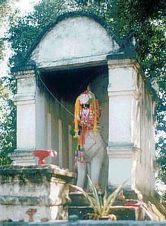
Khuang Singh
See location at Google Maps: Khuang Singh In Google Maps it is Chang Puak
Chao Kawila built "Lion Terrace" in a similar style to "White Elephant Terrace". Surrounded by a pond, the terrace was built in 1801. The lions symbolized the revived power of Chiang Mai to deter the Burmese on the invasion route from the north. They were apparently successful, for the Burmese were never to occupy Chiang Mai again.
The White Chedi
See location at Google Maps: The White Chedi
The Chedi stands as a traffic island near the municipal hall on Wang Sing Kham Road. It is said to contain bones; but whether the bones belong to Haw raiders, Burmese invaders, or brave defenders of Chiang Mai is uncertain. One story says it honors a Thai champion who had a contest with a Burmese champion to see who would stay underwater longer. The Thai won the day by not coming back to the surface.
Sightseeing Guide
City Sights (Historic Monuments)